
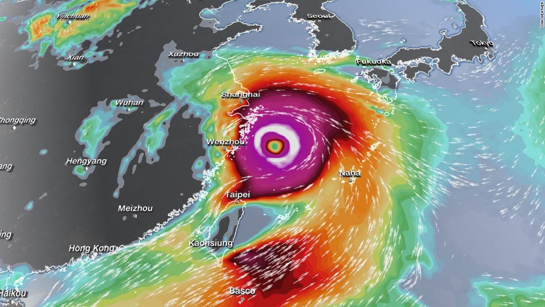
Typhoon In-fa is currently located about 200 miles (320 kilometers) from Okinawa and is starting to move northwest. The storm’s maximum winds are at 95 mph (150 kph), as of the 5 p.m. ET update from the Joint Typhoon Warning Center (JTWC).
In-fa has had slight weakening mid-week due to dry air, thus weakening its thunderstorms, as well as slightly cooler sea surface temperatures.
The good news is no significant strengthening of this storm is expected because of this; but it will still be a Category 2 equivalent hurricane impacting land in the northwest Pacific Ocean.
In-fa will continue to slowly track in the general northwest direction through Friday local time with maximum winds around 100 mph (160 to 165 kph) while impacting Okinawa and other parts of the southern Japanese islands.
In addition to the strong winds, there will continue to be heavy rain. The area in and near Miyakojima, Japan, will be in the bull’s-eye of the heavy rain, with an additional 20-plus inches (500-plus millimeters) of rainfall forecast.
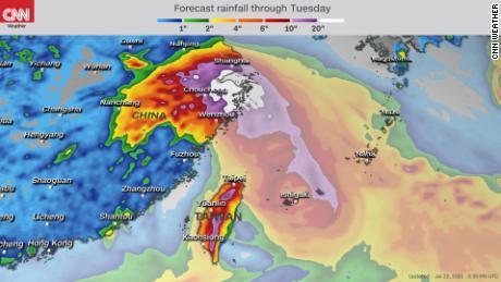
The center of the storm is expected to pass more than 100 miles to the north of Taiwan, but the island will still receive major amounts of rain.
“The mountain chain in Taiwan could squeeze up to a meter’s worth of rain over the region, while Taiwan has been dealing with its worst drought in some 50 years. This amount of rain could lead to catastrophic flash flooding and landslides,” says CNN meteorologist Tom Sater.
About 15 to 20 inches (380 to 500 millimeters) is expected through Saturday local time.
As In-fa pulls away from Japan and Taiwan this weekend, the storm will head toward eastern China and will likely impact the area beginning Sunday.
There are still timing differences on when it will make landfall but it is expected to hit the area between Shanghai and Wenzhou, bringing strong winds and heavy rain.
The JTWC is expecting maximum sustained winds near the center of the storm to be at about 70 mph (110 kph), which is a strong tropical storm. However, the storm may still be at typhoon intensity due to uncertainty in the forecast.
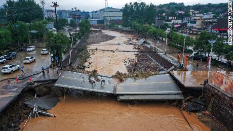
The greater concern is for flooding rains possible for highly populated areas of China.
“Heavy rain will be the story with this as much of it on the Shanghai side of the storm and where most of the moisture is pushed onto shore,” says CNN meteorologist Michael Guy.
“Rainfall up to 10 inches (250 millimeters) will be widespread with higher amounts up to 20+ inches (500+ millimeters) in isolated locations. Flooding will be a major concern from this.”
Potential tropical cyclone during the Olympics
On the heels of Typhoon In-fa is the potential for a new tropical cyclone to form in the western Pacific Ocean.

There are many unknowns surrounding the forecast on this…
Read More: Typhoon In-fa lashes Japan’s southern islands as another tropical threat


