
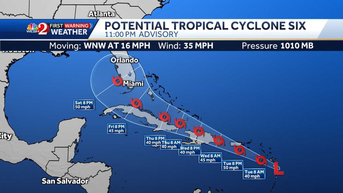
Tropical Storm Fred is likely to form as it continues its path toward Florida, forecasters with the National Hurricane Center say. The system is currently 40 miles east southeast of Dominica and 90 miles southeast of Guadeloupe.The system is moving west-northwest near 16 mph and this is expected to continue during the next few days.On the forecast track, the system is expected to move through the southern Leeward Islands tonight, pass near or over the U.S. Virgin Islands and Puerto Rico late Tuesday and Tuesday night, and near or over Hispaniola on Wednesday. Maximum sustained winds are at around 35 mph with higher gusts. Gradual strengthening is forecast during for the next 48 hours. Tropical Storm Warnings:Puerto Rico, including Culebra and ViequesU.S. Virgin IslandsDominican Republic on the south coast from Punta Palenque eastward and on the north coast from Cabo Frances Viejo eastwardTropical Storm Watches:Martinique and GuadeloupeDominicaSaba and St. EustatiusDominican Republic on the north coast from Cabo Frances Viejo to the Dominican Republic/Haiti borderHaiti from the northern border with the Dominican Republic to GonaivesPHN0eWxlPi5lbWJlZC1yYWRhciB7IGNsZWFyOiBib3RoOyBoZWlnaHQ6IDEwMHZ3OyB9IEBtZWRpYSBvbmx5IHNjcmVlbiBhbmQgKG1pbi13aWR0aDogNDEuMjVyZW0pIHsgLmVtYmVkLXJhZGFyIHsgaGVpZ2h0OiA1MDBweDsgfSB9PC9zdHlsZT4KPHNjcmlwdCB0eXBlPSJ0ZXh0L2phdmFzY3JpcHQiIHNyYz0iaHR0cHM6Ly93aWRnZXRzLWx0cy5tZWRpYS53ZWF0aGVyLmNvbS93eHdpZGdldC5sb2FkZXIuanM/Y2lkPTI4Mjg1MjgwMSI+PC9zY3JpcHQ+CjxkaXYgY2xhc3M9ImVtYmVkLXJhZGFyIiAgcm9sZT0ibWFpbiIgIGFyaWEtbGFiZWw9IlJhZGFyIE1hcCBmcm9tIFRoZSBXZWF0aGVyIENvbXBhbnksIGFuIElCTSBCdXNpbmVzcy4gWW91IG1heSBiZSBhYmxlIHRvIGZpbmQgdGhlIHNhbWUgY29udGVudCBpbiBhbm90aGVyIGZvcm1hdCwgb3IgeW91IG1heSBiZSBhYmxlIHRvIGZpbmQgbW9yZSBpbmZvcm1hdGlvbiwgYXQgV2VhdGhlci5jb20iPgo8d3gtd2lkZ2V0IHR5cGU9Im1hcCIgbGF0aXR1ZGU9IjMwLjIxMDU2MDYiIGxvbmdpdHVkZT0iLTc5LjMyOTA3OCIgbWVudWl0ZW1zPSIwMDE1LDAwMDEsMDAxNywwMDIxIiBtYXBpZD0iMDAyMiIgbWVtYmVyaWQ9IjExNjkiIHpvb21sZXZlbD0iNCIgc3RhbmRhbG9uZT0idHJ1ZSIgb3BhY2l0eT0iLjYiIGZ1bGxzY3JlZW49InRydWUiIGhlYWRlcj0iZmFsc2UiIGpzPSJsdHMiIGFuaW1hdGU9InRydWUiPjwvd3gtd2lkZ2V0Pgo8L2Rpdj4=Related: How to choose your storm prep supplies, develop a plan Forecasters said last week that conditions for an above-average season are even more favorable than what had been previously predicted.National Oceanic and Atmospheric Administration forecasters monitoring oceanic and atmospheric patterns say conditions are now more favorable for above-normal hurricane activity because El Nino has ended.NOAA’s Climate Prediction Center previously put the chances for an above-normal season at 30%. That is now up to 45% in the latest outlook.The likelihood of near-normal activity is now at 35%, and the chance of below-normal activity has dropped to 20%, forecasters said.The number of predicted storms is also greater with NOAA now expecting 10-17 named…
Read More: Tropical Storm Fred likely to form overnight, forecasters say


